
The Village
Natland is a village and civil parish in the former county of Westmorland, now part of Cumbria (and from 2023, the Westmorland and Furness unitary authority). It lies approximately 3 km (2 miles) south of Kendal, on the eastern bank of the River Kent.
The parish covers 3.61 km² (361 hectares) of open countryside, and is home to around 1,000 residents. The village retains its rural character, surrounded by farmland and with views towards the Lakeland fells and the Howgill Fells.
History
Name and early evidence
The place-name Natland is first recorded between
1170 and 1180. The
Survey of English Place-Names
derives it from an Old Norse personal name and lundr,
a small wood
or a sacred grove
— most likely
Nati's wood
. The name Nati is known independently only
as a giant in the Norse Edda, so the survey suggests the
related personal name Nate may be the more probable source;
it also allows that the first element could instead be Old Norse
nata, nettle
, or a root nat- meaning
wet
(compare Old English næt). A charmingly imaginative
alternative offered by
Nicolson and Burn's 1777 history of Westmorland traced it instead to Latin
nativi, bondsmen said to have been quartered at Natland to serve
the lord of Kendal Castle; the Old Norse derivation is now the accepted
reading. An earlier place-name associated with the area,
Bodelforde (ford near the dwelling
), appears in a
Domesday-era survey of 1086; the ford itself, probably across the
River Kent between Natland and Helsington, is now lost. Other early
names in the township include Cracalt
(first recorded 1290, nook of land frequented by crows
) and
Oxenholme (1274, water meadow where oxen were pastured
).
A multivallate Iron Age hill-fort survives on Castlesteads, the summit of The Helm. In the low ground at the parish's northern tip, where the River Kent bends sharply, stood the Roman auxiliary fort of Alauna. It was built as a turf-and-timber structure in the late first century AD, rebuilt in stone during the reign of Hadrian (around AD 130), and abandoned during the Antonine reoccupation of southern Scotland (c. 142–165) before being reoccupied and finally left in the late third or very early fourth century. Extra-mural civilian settlement flanked the northern and south-eastern exit roads. A long drought in 1887 revealed the fort's streets and buildings; formal excavations followed in the 1930s and the 1970s.
Medieval Natland
In the 1170s William II de Lancaster, lord of the barony of Kendal, granted fifteen pounds' worth of land, including "Natalund and Bothelford", to Gervase Deincourt for his homage and service. In 1246 Gervase's descendant Ralph Deincourt was granted a licence for a private chapel at his "court at Natland", in exchange for his share of Kendal church and a small holding at Whinfell. Ralph's two sons died without issue by 1271, and Natland passed with Sizergh to Ralph's daughter Elizabeth, whose husband was Sir William Strickland (d. c. 1305). The lordship has descended in the Strickland family ever since — a connection that endures into the twenty-first century: the village green and The Helm remain common land under Strickland ownership.
An extensive walled deer park covered part of the township in the medieval period, still shown on Ellis's map of Westmorland as late as 1765 but described in 1692 as having been disparked "long since". Many of Natland's farms — Watercrook, Natland Mill, and Cracalt among them — are of medieval origin, though the oldest surviving buildings date only from the sixteenth and seventeenth centuries.
The Natland Academy, 1674–83
In 1674 the dissenting minister Richard Frankland (1630–1698) moved his celebrated Nonconformist academy to Natland, at the invitation of local Dissenters. Frankland, a Cambridge-educated preacher who had refused to conform to the Church of England at the 1662 Restoration settlement, taught theology and the classics to young men denied entrance to the English universities. His academy at Natland ran for roughly nine years, until the enforcement of the Five Mile Act (1665) in early 1683 forced him to move again. Frankland's academies at their various locations — Natland among them — trained 304 students in total, several of whom became prominent figures in the early Nonconformist tradition.
Country houses of the nineteenth century
Several substantial villas were built in the township during the nineteenth century — three of which resurface in the story of the war memorial. Helm Lodge, the largest, was built in 1824 by the Lancaster architects Francis and George Webster for the Kendal banker William Dilworth Crewdson; it survives Grade II listed and was converted into private dwellings in 1988. Newlands, at the south of the township, was bought by the Fothergill family in 1877, and served as their family seat and poultry farm; the family later inherited Natland Hall and Natland Abbey too. It was from this household that Pilot Officer John Miles Fothergill MC went to war in 1941. Helm Bank, built by the Keesey family in the late nineteenth century, sits alongside Fisherflatt, where Captain George Ernest Howard Keesey lived until his death on the Somme in September 1916. His son Captain John Howard Keesey — nine months old when his father was killed — grew up at Fisherflatt and later fell at Arnhem in 1944 as an army doctor with the 1st Airborne Division.
A more curious survival is Natland Abbey, a sixteenth-century
house near the village that was never in fact an abbey — its owner Edward
Shippard felt obliged to point out in 1779, my house never was an abbey
.
The name likely came from the medieval tithes of Natland having been held by
St Mary's Abbey, York, until the Dissolution.
Industry and the nineteenth century
The Lancaster Canal — engineered by John Rennie and locally nicknamed the "Black and White Canal" for its two principal cargoes, Cumbrian limestone travelling south and Lancashire coal travelling north — ran through the western edge of the parish. Authorised by Act of Parliament in 1792, its Northern Reaches opened on 19 June 1819 to connect Preston with Kendal, passing through Natland on their way. The Hincaster Tunnel, the only tunnel on the entire canal, lay just 3 km (2 miles) south of the village. In its heyday the canal ran an Express Packet Boat that made the Preston-to-Kendal journey in ten hours — locks-free, and much loved by passengers, who went on using it for years after the railway arrived. The Kendal section was closed in 1941–42 because of leakage and formally ceased operation in 1947; the stretch between Kendal and Crow Park was subsequently drained and used as a refuse tip. The M6 motorway later severed twenty-three kilometres (fourteen miles) of the Northern Reaches at Tewitfield, though the restoration campaign continues.
The Lancaster and Carlisle Railway opened Oxenholme station in 1846, followed a year later by the Kendal and Windermere branch line. Oxenholme became a junction, and the hamlets of Oxenholme and Helmside grew around it: twenty-five brick cottages went up at Helmside for railway employees in 1885, followed by Station Road, Natland Terrace, and Hill Place before the century closed. The station was rebuilt and enlarged in 1881–82, when the level crossing was replaced by the horseshoe bridge that still spans the line. Sandstone was quarried on The Helm through the nineteenth and early twentieth centuries. Natland's population climbed from 204 in 1801 to 464 by 1891 and 690 by 1931; council housing was added at Bolefoot in 1921 and, after the war, at Park Close in 1947. In 1935, land east of Burton Road — including Oxenholme village — was transferred to Kendal under the Westmorland Review Order, which is why present-day Natland civil parish covers only 361 ha (892 acres) rather than the earlier 467 ha (1,155 acres).
The caves — and the Treacle Mine
For generations, villagers passed down stories of the "Natland Treacle Mines" — a long-lost subterranean workings said to lie somewhere below The Helm. Two "soak-aways" of unknown depth around the village kept the tale in circulation; and, according to The Westmorland Gazette, local memory of a calf or sheep occasionally falling into some hidden void may have helped the legend along.
The story turned out to have a foundation in fact. On 21 October 1983 the ground collapsed under a recently-laid water main in a field on the outskirts of Kendal. The experienced Sedbergh caver Jeff Clegg was asked by the North West Water Authority to investigate; with his fellow caver Graham Hudson, he found himself in a major, previously unknown cave system stretching for more than 2.5 km (a mile and a half) between Oxenholme and Natland. The passages, believed to date to the Ice Age, contained water cascades, a bell-shaped chamber, and the very rare helical mineral formations known as helictites. One caving expert described the find as "very important".
Clegg and Hudson explored roughly 600 metres (2,000 feet) of the main passage; after four surveying expeditions, 250 metres were mapped in detail for the water authority. The discovery was kept quiet during the survey work, and the entrance was subsequently sealed by the water authority with ten cubic metres of concrete. The Treacle Mine, in other words, is still down there — and, save for a small stretch, it remains unexplored.
Timeline
- Iron AgeEarthworks on The Helm — probably a small hill-fort.
- c. 90–400 ADRoman auxiliary fort at Watercrook (probably Alauna) occupies a bend of the Kent at the parish's northern tip.
- 1086Domesday-era place-name Bodelforde recorded in the area; the settlement lies in the barony of Kendal.
- 1170sWilliam II de Lancaster grants land at Natalund to Gervase Deincourt.
- 1170–80First recorded use of the name Natland.
- 1246Ralph Deincourt granted licence for a chapel at his court at Natland.
- c. 1271Deincourt line ends; Natland descends via Elizabeth Deincourt's marriage to Sir William Strickland, and stays with the Stricklands of Sizergh ever after.
- 1674–83Richard Frankland's Nonconformist academy operates at Natland until the Five Mile Act forces it to move.
- 1717Chapel described as "ruinous and unused."
- 1735Chapel rebuilt.
- 1777First school building constructed in the village, endowed by a local bequest.
- 1792Lancaster Canal authorised by Act of Parliament; would eventually link Preston with Kendal via Natland's western parish.
- 1819Northern Reaches of the Lancaster Canal opened, extending the waterway from Tewitfield through Natland to Kendal.
- 1825Church rebuilt; school rebuilt in the same year.
- 1846Oxenholme station opens on the Lancaster and Carlisle Railway; the hamlets of Oxenholme and Helmside grow around it.
- 1847Kendal and Windermere branch line opens, making Oxenholme a junction.
- 1879Church and school both enlarged to accommodate a growing population.
- 1881–82Oxenholme station rebuilt and enlarged; the level crossing replaced by the horseshoe bridge that still spans the line.
- 1882St Mark's Home for Boys founded.
- 1894The Children's Society takes over St Mark's Home.
- 1909–10St Mark's Church rebuilt to its current form by architects Austin and Paley of Lancaster.
- 1914–18First World War — 17 men associated with Natland and St Mark's Home gave their lives.
- 1935Land east of Burton Road, including Oxenholme village, transferred to Kendal under the Westmorland Review Order; Natland parish reduced from 467 ha (1,155 acres) to 361 ha (892 acres).
- 1939–45Second World War — nine men from Natland are remembered on the memorial.
- 1947Lancaster Canal ceases operation.
- 1952Coronation oak planted on the village green for the accession of Queen Elizabeth II.
- 1967A new St Mark's Primary School opens; the old school is demolished in 1969.
- 1974Natland becomes part of South Lakeland district, Cumbria. St Mark's Home ceases full-time residential operation.
- 1983Over 2.5 km (1½ miles) of previously unknown Ice Age caves discovered between Oxenholme and Natland — the "Treacle Mine" of local legend.
- 1994St Mark's Home closes permanently.
- 2008A second plaque added to the war memorial, recognising 11 further men with connections to St Mark's Home.
- 2018Armistice centenary exhibition held in St Mark's Church.
- 2023Westmorland and Furness unitary authority created, replacing South Lakeland.
St Mark's Church
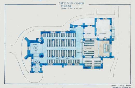
The parish church of St Mark stands at the heart of the village. A chapel is first recorded here in 1246; the present building was rebuilt in 1909–10 by the noted Lancaster architects Austin and Paley, replacing earlier chapels on the site. It serves the parish of Natland and Oxenholme, and is home to the village war memorial — a stone cross in the churchyard accompanied by bronze plaques inside the church.
Visit the St Mark's Church website →
St Mark's Church of England Primary School
Natland has had a village school for generations. According to the Cumbria County History Trust, a school building was first constructed in 1777, endowed by the will of Charles Shippard. A new school was erected in 1825 and enlarged in 1879 and again in 1909 to keep pace with a growing population. The school moved to its current site and building in 1967; the old school was demolished two years later.
Today St Mark's Church of England Primary School is a small, family-oriented village school serving children aged 4 to 11. It operates as a Voluntary Aided school within the Church of England education framework.
John Chandler — whose research underpins this site's war memorial section — served as Headteacher from 1985 to 2005.
Visit the St Mark's School website →
St Mark's Home for Boys
From 1882 to 1994 Natland was home to a children's home with a profound impact on the village's history. Founded in 1882 by the Rev. Charles Whitaker and later taken over by the Children's Society in 1894, St Mark's Home housed around twenty-five boys aged 7–15 at its peak. It later accepted girls from 1960 before closing as a full residential home in 1974, operating as a holiday centre until 1994.
The Home plays a central role in the Natland war memorial story: eleven of the seventeen WW1 names on the memorial were "inmates" (as residents were called) at St Mark's Home. Many were sent onward to sister homes in Canada and subsequently joined the Canadian Expeditionary Force.
The Home installed running water and drainage in 1899, enabling swimming lessons, and ran an active Scout Troop. Its boys regularly won regional swimming medals.
Read more about St Mark's Home on Hidden Lives Revealed →
The village green and The Helm
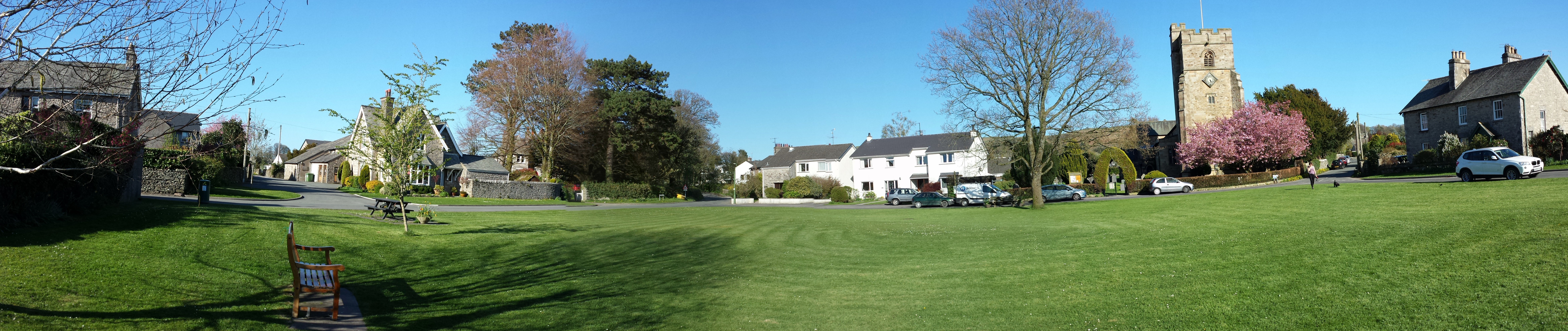
The village green sits at the heart of Natland, where the roads from Kendal, Sedgwick, and Oxenholme meet. At its centre stands a Coronation oak, planted in 1952 to mark the accession of Queen Elizabeth II. To the east, the whaleback ridge of The Helm rises to 185 m and gives Natland its most recognisable landmark — a fine walk from the village along the old track, with panoramic views across the Lyth Valley to the Lakeland fells and, on a clear day, north as far as Blencathra. Both the green and The Helm are common land, held to this day by the Strickland family of Sizergh Castle, heirs to a lordship that has descended in the same line since the twelfth century.
Historical maps
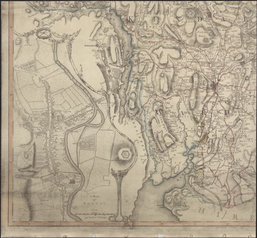
Natland appears on Thomas Jefferys's The County of Westmoreland of 1770, the south-west sheet of which covers Kendal and the surrounding parishes. The village sits a short way south of Kendal on the road to Lancaster, with the River Kent to the east and the powder works at Sedgwick a little further south.
Sources
This page is largely drawn from the following works. Any errors are the site's, not theirs.
- Sarah Rose, Natland , draft parish history for the Victoria County History of Cumbria Project (May 2015).
- W. Inglesfield, Natland and Oxenholme: the Story of a Westmorland Village (Kendal, 2006).
- Nicolson & Burn, The History and Antiquities of the Counties of Westmorland and Cumberland (London, 1777).
- Canal & River Trust, History of the Lancaster Canal .
- "From the files of The Westmorland Gazette" — 21 October 1983 (on the discovery of the caves).
- Wikipedia: Natland and its cited references, including Richard Frankland (tutor).
Maps
For walking routes, a ground-level Street View, aerial imagery, Ordnance Survey reference, and photographs of the area, see the dedicated Maps page →
Linked open data
Natland is described in a number of open civic and geographic datasets — all of them public-sector, civic-society, or community-maintained rather than commercial. These links are useful starting points for anyone researching the village's administrative, statistical, or geographic identity.
- Wikidata — Q3242648 · the machine-readable "identity card" for Natland, linking to Wikipedia articles in every language, VIAF, and other authorities.
- MapIt (by mySociety) — Natland civil parish · parish boundary, ONS code, Ordnance Survey grid reference, and a list of neighbouring areas.
- ONS statistics — the
Explore local statistics profile for Natland
· population, age structure, and other small-area figures from the
2021 Census. Natland's current GSS parish code is
E04002635(older ONS code16UG052); the ONS Open Geography Portal holds the parish boundary layer these codes are attached to. - OpenStreetMap — village-centre node 29670280 · and the parish boundary relation 8310800.
- Cumbria County History Trust — Natland township article · the most authoritative single narrative of the parish's history currently available online.
- Church Heritage Record (Church of England) — St Mark's Church, Natland · the national heritage record for the parish church, run by the Church Buildings Council: listing status, fabric significance, history, and interior features.
- Historic England — list of designated heritage assets in Natland · scheduled monuments, listed buildings, and conservation-area references.